

Topographical for Building Permit
Topographic diagrams are a fundamental and essential element for the issuance of a building permit. They involve the mapping of the plot or property where the construction will take place, as well as all of its characteristics, such as boundaries, elevation differences, surrounding areas, and the mapping of the entire building block. The accuracy of the topographic diagram is crucial, as it directly affects the acceptance or rejection of the building permit by the competent authorities.
With our experience in the field of surveying and construction, we guarantee the high quality and absolute accuracy of every topographic diagram. Using modern technological tools, we ensure that the topographic diagram goes through all necessary stages, from the initial mapping to final approval, quickly and reliably.
The process of obtaining a building permit requires the submission of various technical documents, with the topographic diagram being the most essential of these. It includes details such as neighboring properties, the integration of the plot into the urban planning map, infrastructure (roads, networks), and any legal restrictions or permissible land uses.
By collaborating with us, you ensure that your topographic diagram will be in compliance with current regulations, while also allowing you to proceed quickly and without delays in the process of obtaining the building permit.


Topographical for Building Permit
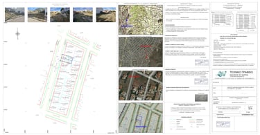
Sample of Topographic Diagram for Building Permit

Contact Form
Home
About Us
Contact
Useful Links
Adress
Tralleon 136, Galatsi 111 46
Phone Number
+30 694 590 6300