

Topographic Surveys Within City Plan
Topographic diagrams for properties within urban plans are one of the most important tools for the accurate mapping of boundaries and characteristics of a property. This process is essential for any project carried out in urban areas, as it ensures that the property complies with urban planning legislation and building regulations.
With over 20 years of experience in surveying, we specialize in creating topographic diagrams within urban plans, providing precise data and comprehensive solutions. The topographic diagrams we prepare include the mapping of property boundaries, buildings, as well as surrounding infrastructure and road networks.
Using modern technological tools and software, we ensure that every plan is accurate and fully compliant with current urban planning regulations. Topographic diagrams are essential for many procedures, such as issuing building permits, property transfers, and the regularization of unauthorized constructions.
We offer complete support and advice, ensuring that every project proceeds smoothly and efficiently. Whether for small or large plots, the topographic diagrams we prepare are known for their accuracy and completeness, while also providing full guidance on the requirements and regulations governing your area.


Topographic Surveys Within City Plan
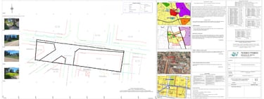
Sample of Topographic Diagram within Urban Plan

Contact form
Home
About Us
Contact
Useful Links
Adress
Tralleon 136, Galatsi 111 46
Phone Number
+30 694 590 6300